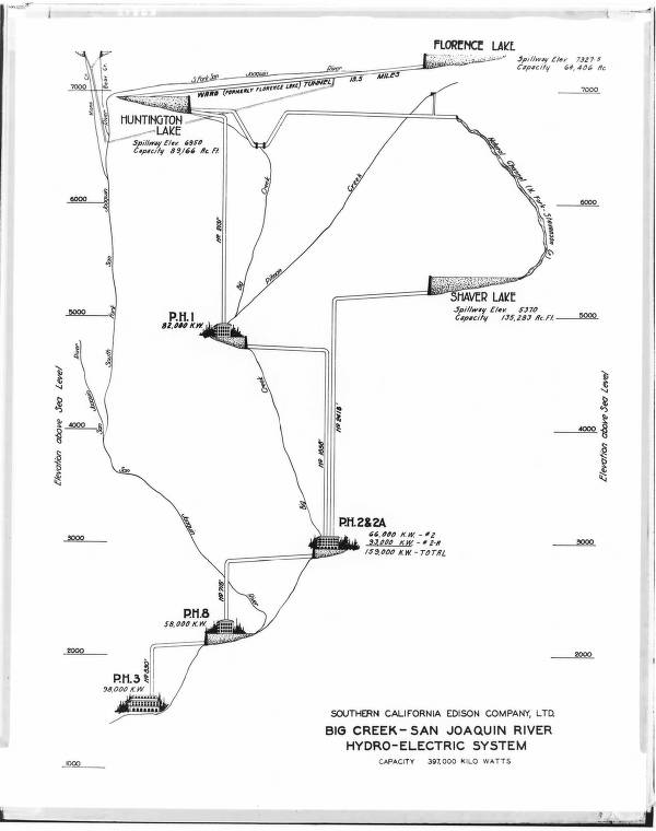
Diagrammatic Elevation Profile Map of Big Creek
Dublin Core
Title
Diagrammatic Elevation Profile Map of Big Creek
Description
Inspired and motivated by the droughts of southern California and the need for clean energy in the early 20th century, the Big Creek Hydroelectric Project was ambitious, as it cleverly utilizes the drastic drop in elevation to lead the water from Sierra-Nevada mountain towards southern California basin. This archived item is from the Huntington Digital Library, a photograph that shows a hand drawn map that describes such change in elevation as a part of the design of the system. Perhaps dated before the completion of Big Creek Powerhouse 3 in 1923, the map is a schematic plan before the construction, as shown in the title of a similar map: “Big Creek Project as envisaged in 1920” (Jackson 82).
Although it was common for American engineering maps in the 1920s to be hand-drawn, the majority still aimed to remain relatively close to scale and provide geographic directions, such as the map celebrating the opening of a California highway (Roth 546). Differently, this item does not show geographical clarity or have a sense of direction. The “x-axis” is unclear, as is the placement of the Big Creek Powerhouses. Instead it is more of a scientific / engineering graph that focuses on the change of elevation versus the relative location of numerous Powerhouses and lakes around, where the “y-axis” shows elevation scale. It also has a blend of artistic besides the scientific rigorous, through the intricate hand drawn symbols for the Powerhouses. Even within the series of Big Creek Hydroelectric Project maps, it is still unique in this item for the artistic depiction of the Powerhouses symbols, which perhaps is the unknown map maker’s spontaneous subject of interest.
Bishop, G. Haven. Big Creek General - Diagrammatic elevation profile map of Big Creek. The Huntington Digital Library. https://hdl.huntington.org/digital/collection/p16003coll2/id/36923/rec/17
Jackson, Donald C. Building the Ultimate Dam: John S. Eastman and the Control of Water in the West. University Press of Kansas, 1995, pp.59-83.
Roth, Matthew W. Mulholland Highway and the Engineering Culture of Los Angeles in the 1920s. Technology and Culture, vol. 40, no.3, 1999, pp.545-575. https://www.jstor.org/stable/25147359
Creator
Bishop, G. Haven
Source
Huntington Digital Library
Date
undated, probably around 1920s
Format
Photo of a Map
Citation
Bishop, G. Haven, “Diagrammatic Elevation Profile Map of Big Creek,” Electrifying Los Angeles, accessed July 2, 2026, https://www.electrifying.collopy.net/items/show/7.