Electrifying Maps - Caltech & Big Creek Infrastructure Maps
Electrical infrastructure in the 1920s helped illuminate greater Los Angeles and Caltech. The distinctive hand-drawn style of engineering maps from this period signifies the importance of that infrastructure. From the artistic-engineering blend of the Powerhouses in the Big Creek Projects to early maps of the Caltech campus, these maps convey the importance of both geological reference and symbolism.
These maps selectively highlight the features most closely tied to infrastructure rather than attempting to replicate the real world in exact 1:1 detail. Beyond serving as scientifically rigorous representations, they were also used for their symbolic meaning.
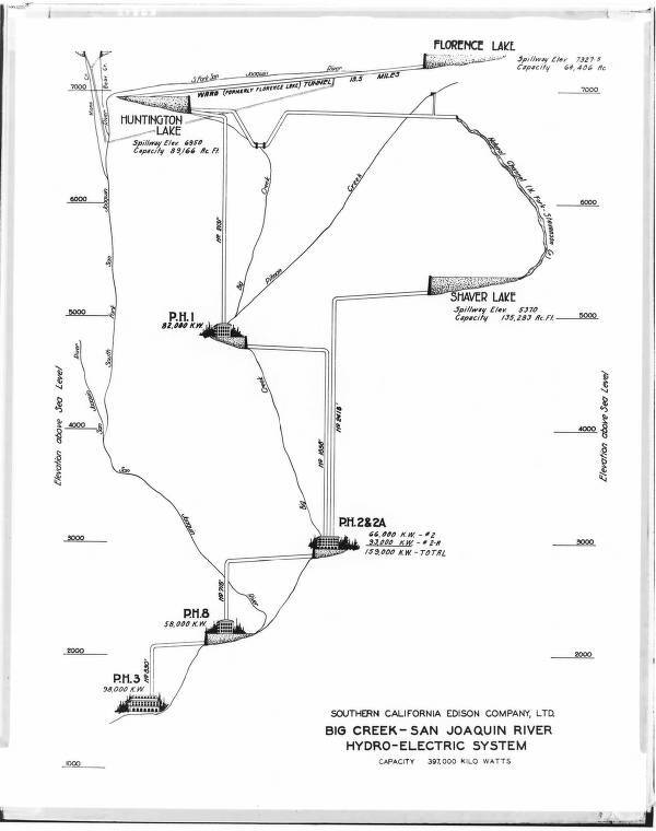
Inspired and motivated by the droughts of southern California and the need for clean energy in the early 20th century, the Big Creek Hydroelectric Project was ambitious, as it cleverly utilizes the drastic drop in elevation to lead the water from Sierra-Nevada mountain towards southern California basin. This archived item is from the Huntington Digital Library, a photograph that shows a hand drawn map that describes such change in elevation as a part of the design of the system. Perhaps dated before the completion of Big Creek Powerhouse 3 in 1923, the map is a schematic plan before the construction, as shown in the title of a similar map: “Big Creek Project as envisaged in 1920” (Jackson 82).
Although it was common for American engineering maps in the 1920s to be hand-drawn, the majority still aimed to remain relatively close to scale and provide geographic directions, such as the map celebrating the opening of a California highway (Roth 546). Differently, this item does not show geographical clarity or have a sense of direction. The “x-axis” is unclear, as is the placement of the Big Creek Powerhouses. Instead it is more of a scientific / engineering graph that focuses on the change of elevation versus the relative location of numerous Powerhouses and lakes around, where the “y-axis” shows elevation scale. It also has a blend of artistic besides the scientific rigorous, through the intricate hand drawn symbols for the Powerhouses. Even within the series of Big Creek Hydroelectric Project maps, it is still unique in this item for the artistic depiction of the Powerhouses symbols, which perhaps is the unknown map maker’s spontaneous subject of interest.
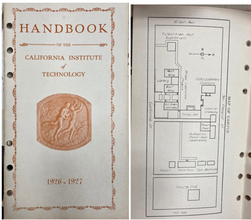
Every incoming Caltech undergraduate student receives the latest edition of the campus handbook, the little t. In the 2025–2026 edition, the little t has the “primary purpose of helping frosh get acquainted with the Institute” (Emily et.al “Preface”). However, the little t did not exist in its current form during Caltech’s earliest years. In 1926, it still bore its original name, Handbook of the California Institute of Technology. Even so, the handbook served a similar purpose.
One section in particular has remained present from 1926 to 2026 for over a hundred years: the Caltech campus map and directory of buildings. Although the 2025–2026 little t provides only a link to a virtual interactive map, the 1926 handbook includes an engineering-style hand-drawn map, reproduced at the very front of the book. The building blocks are represented in little rectangular boxes, which does not represent the real shape of the infrastructures from an aerial view. They are more served as symbols that tell students where to go.
Interestingly, the 1923 Caltech Catalogue has more detailed descriptions of the buildings on the map, but note that some buildings, such as Caltech’s Electrical System, are temporary (Catalogue 44).
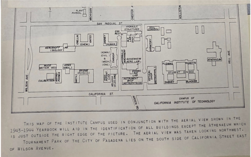
This hand-drawn engineering map, later reprinted in the 1943-1944 yearbook, depicts the Caltech campus during that academic year. Compared with the 1926 campus map, it still focuses on the southern portion of campus, but it includes significantly more buildings with names that remain familiar today, with the buildings not as rectangular symbols, but actual aerial view architecture.
Interestingly, many of the “temporary buildings” mentioned earlier in the 1923 Caltech Catalogue, such as the powerplant, had changed location by the time of the 1943 - 1944 map (Catalogue 44). One interesting detail mentioned in the 1923 catalogue is the department of military engineering. It may have been the precursor to the Guggenheim Aeronautical Laboratory at Caltech (GALCIT), or "Guggenheim Aero Lab” on this map. Established in 1928, GALCIT later received U.S. federal support for rocket science research (“Caltech History”). In 1943, “the Army Air Force asked GALCIT to study the possible use of rockets to propel long-range missiles as well as develop missiles for field use” (“Caltech History”).
Bibliography:
First item:
Bishop, G. Haven. Big Creek General - Diagrammatic elevation profile map of Big Creek. The Huntington Digital Library. https://hdl.huntington.org/digital/collection/p16003coll2/id/36923/rec/17
Jackson, Donald C. Building the Ultimate Dam: John S. Eastman and the Control of Water in the West. University Press of Kansas, 1995, pp.59-83.
Roth, Matthew W. Mulholland Highway and the Engineering Culture of Los Angeles in the 1920s. Technology and Culture, vol. 40, no.3, 1999, pp.545-575. https://www.jstor.org/stable/25147359
Second item:
Bulletin of the California Institute of Technology Catalogue. Published by the Institute, vol. 32, no. 101, Dec. 1923.
Handbook of the California Institute of Technology. Caltech. 1926-1927
Yu, Emily, Foster, Melissa, Yang, Benjamin. The little t 2025-2026. Published by ASCIT
Third item:
Bulletin of the California Institute of Technology Catalogue. Published by the Institute, vol. 32, no. 101, Dec. 1923.
“Caltech History - 14 Facts About Caltech History” Archives & Special Collections, Caltech Library. https://library.caltech.edu/archives/about/caltech-history
“Campus of California Institute of Technology” Caltech. 1943-1944.